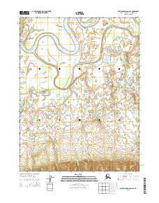
2015 Map of Baird Mountains A-2 SE
USGS Topo · Published 2015About this map
Kobuk Valley National Park encompasses a significant portion of this Arctic landscape, where the meandering Kobuk River dominates the northern terrain. The river’s winding course creates a complex network of oxbows and wetlands, joined by the Kallarichuk River as it flows from the northwest. To the south, the topography shifts toward the foothills, drained by smaller waterways including Elaroniluk Cr and Tetilesook Cr. This 2015 survey provides a clear view of the wilderness character of the region, emphasizing the natural hydrography that has dictated movement and seasonal land use in the Northwest Arctic for generations. The map's detail allows for the study of drainage patterns across the survey boundaries of t20n r5w and t19n r4w, illustrating the transition from riverine lowlands to rising interior slopes.
Find a feature on this map
9 named features on this map. Tap any name to fly to it.
Don’t see what you’re looking for? This feature index may not catch every label — zoom into the map to look around manually.
Map Details
Editions of this 2015 Baird Mountains A-2 SE Map
This is the sole edition of this map. No revisions or reprints were ever made.
Other maps of this area

1951 · Baird Mountains
USGS Topo · 1:250,000

1951 · Selawik
USGS Topo · 1:250,000

1955 · Baird Mountains A-1
USGS Topo · 1:63,360

1955 · Selawik D-2
USGS Topo · 1:63,360

1955 · Baird Mountains A-2
USGS Topo · 1:63,360
1955 · Selawik D-1
USGS Topo · 1:63,360

1956 · Baird Mountains
USGS Topo · 1:250,000

1957 · Selawik
USGS Topo · 1:250,000

1965 · Baird Mountains
USGS Topo · 1:250,000
2015 · Baird Mountains A-2 NW
USGS Topo · 1:25,000