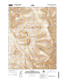
2015 Map of Baird Mountains C-3 NW
USGS Topo · Published 2015About this map
Noatak National Preserve encompasses the majority of this Arctic landscape, where high-latitude drainage systems define the movement of water across the Baird Mountains. The map illustrates a transitional wilderness zone where the preserve meets the northern boundary of Kobuk Valley National Park in the southeastern corner. Within this protected corridor, three primary watercourses—Nakolikrok Cr, Sapun Cr, and Anaktok Cr—carve through the high-elevation terrain. The cartography emphasizes the pristine hydrography of the Northwest Arctic, showing how these creeks navigate the complex topography of the Brooks Range foothills before their eventual confluence with larger river systems downstream.
Find a feature on this map
9 named features on this map. Tap any name to fly to it.
Don’t see what you’re looking for? This feature index may not catch every label — zoom into the map to look around manually.
Map Details
Editions of this 2015 Baird Mountains C-3 NW Map
This is the sole edition of this map. No revisions or reprints were ever made.
Other maps of this area

1951 · Baird Mountains
USGS Topo · 1:250,000

1955 · Baird Mountains D-4
USGS Topo · 1:63,360

1955 · Baird Mountains D-3
USGS Topo · 1:63,360

1955 · Baird Mountains C-4
USGS Topo · 1:63,360

1955 · Baird Mountains C-3
USGS Topo · 1:63,360

1956 · Baird Mountains
USGS Topo · 1:250,000

1965 · Baird Mountains
USGS Topo · 1:250,000
2015 · Baird Mountains D-3 SW
USGS Topo · 1:25,000
2015 · Baird Mountains C-3 NE
USGS Topo · 1:25,000
2015 · Baird Mountains C-4 NE
USGS Topo · 1:25,000