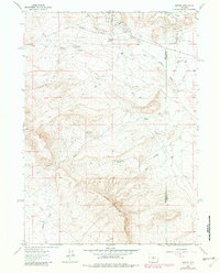
1961 Map of Bairoil
USGS Topo · Published 1982About this map
The Oil Field operations of the northern Great Divide Basin define this industrial and desert landscape at the border of Sweetwater Co and Carbon Co. In the early 1960s, the isolated settlement of Bairoil served as the hub for local resource extraction, supported by residential sites like Wertz Camp and South Camp. This 1981 photorevised edition shows an extensive network of infrastructure, including a Landing Field, water tanks, and a complex of pipelines moving petroleum products across the arid terrain. Natural drainage and water management are critical features here, seen in the winding courses of Lost Soldier Creek and several catchment points such as White Water Reservoir and Iron Springs Reservoir. The topography rises sharply toward the south at Bull Springs Rim, while a series of prospects and drill holes dot the landscape, illustrating the intensity of geological exploration in this part of Wyoming.
Find a feature on this map
24 named features on this map. Tap any name to fly to it.
Don’t see what you’re looking for? This feature index may not catch every label — zoom into the map to look around manually.
Map Details
Editions of this 1961 Bairoil Map
2 editions found
Other maps of this area

1955 · Casper
USGS Topo · 1:250,000

1958 · Casper
USGS Topo · 1:250,000

1960 · Separation Rim
USGS Topo · 1:24,000

1960 · Bull Springs
USGS Topo · 1:24,000

1960 · Chicken Spring
USGS Topo · 1:24,000

1961 · Lamont
USGS Topo · 1:24,000

1961 · Hadsell Spring
USGS Topo · 1:24,000

1961 · Bairoil
USGS Topo · 1:24,000

1962 · Casper
USGS Topo · 1:250,000

1962 · Whiskey Peak
USGS Topo · 1:24,000