
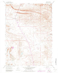
1961 Map of Lamont
USGS Topo · Published 1965About this map
The small settlement of Lamont serves as a lone outpost in this 1961 portrait of the high Wyoming desert. Located within Carbon County, the landscape is defined by the ephemeral waters of Lost Soldier Lake and Mahoney Lake, alongside the shifting geography of Sand Dunes to the east. The map records a working landscape of resource extraction and ranching, featuring numerous Oil Wells, a Gas Well, and scattered Prospects that indicate the subterranean economy of the era.
Find a feature on this map
21 named features on this map. Tap any name to fly to it.
Don’t see what you’re looking for? This feature index may not catch every label — zoom into the map to look around manually.
Map Details
Editions of this 1961 Lamont Map
2 editions found
Other maps of this area

1955 · Casper
USGS Topo · 1:250,000

1958 · Casper
USGS Topo · 1:250,000

1960 · Separation Rim
USGS Topo · 1:24,000

1960 · Bull Springs
USGS Topo · 1:24,000

1960 · Boggy Meadows
USGS Topo · 1:24,000

1961 · Lamont NE
USGS Topo · 1:24,000

1961 · Bairoil
USGS Topo · 1:24,000

1962 · Casper
USGS Topo · 1:250,000

1962 · Whiskey Peak
USGS Topo · 1:24,000
1962 · Youngs Pass
USGS Topo · 1:24,000