
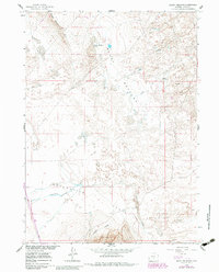
1960 Map of Boggy Meadows
USGS Topo · Published 1962About this map
Boggy Meadows Lake sits at the heart of this high desert terrain, flanked by the prominent Boggy Rim to the northwest. This 1960 field-checked survey reveals a landscape defined by seasonal water patterns and the vast Separation Flats stretching across the southern portion of the quadrangle. The presence of Rendle Spring and Stone Creek indicates the critical importance of water sources in this part of Carbon County. To the west, the Separation Rim provides a natural boundary, while Separation Creek meanders through the flats, illustrating the drainage network of the Missouri River Basin. The inclusion of Riddle Cut and Rendle Draw suggests local family names tied to the land's history, offering valuable coordinates for genealogists tracing ancestral holdings or grazing territories in the early 1960s.
Find a feature on this map
11 named features on this map. Tap any name to fly to it.
Don’t see what you’re looking for? This feature index may not catch every label — zoom into the map to look around manually.
Map Details
Editions of this 1960 Boggy Meadows Map
2 editions found
Other maps of this area

1953 · Ferris
USGS Topo · 1:24,000

1953 · Riddle Cut
USGS Topo · 1:24,000

1953 · Rawlins NW
USGS Topo · 1:24,000

1954 · Rawlins
USGS Topo · 1:250,000

1955 · Casper
USGS Topo · 1:250,000

1956 · Rawlins Peak
USGS Topo · 1:62,500

1958 · Rawlins
USGS Topo · 1:250,000

1958 · Casper
USGS Topo · 1:250,000

1960 · Separation Rim
USGS Topo · 1:24,000

1961 · Lamont NE
USGS Topo · 1:24,000