
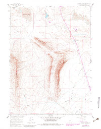
1960 Map of Separation Rim
USGS Topo · Published 1962About this map
The Separation Rim and its prominent Separation Point dominate this high-desert region of Wyoming, where the landscape is defined by massive geological escarpments and interior drainage basins. In the early 1960s, this area of Carbon County remained largely undeveloped, characterized by seasonal water features like Soda Lake and Bull Spring Lake that gather in the depressions of the Flats. Evidence of human activity is concentrated in specific industrial and ranching landmarks, such as the Strip Mine located in the northern sections and scattered infrastructure including a Corral and a long-distance Pipeline. The drainage patterns are clearly marked by Bulls Creek, Separation Creek, and Cold Spring Draw, illustrating the complex hydrology of the high plains before significant modern alteration. Further west, the Coyote Springs Rim forms another significant vertical break in the terrain, accessible only by a few unimproved tracks and the corridor of Route 287.
Find a feature on this map
15 named features on this map. Tap any name to fly to it.
Don’t see what you’re looking for? This feature index may not catch every label — zoom into the map to look around manually.
Map Details
Editions of this 1960 Separation Rim Map
2 editions found
Other maps of this area

1954 · Rawlins
USGS Topo · 1:250,000

1955 · Casper
USGS Topo · 1:250,000

1956 · Rawlins Peak
USGS Topo · 1:62,500

1958 · Rawlins
USGS Topo · 1:250,000

1958 · Casper
USGS Topo · 1:250,000

1960 · Bull Springs
USGS Topo · 1:24,000

1960 · Buck Draw
USGS Topo · 1:24,000

1960 · Boggy Meadows
USGS Topo · 1:24,000

1961 · Lamont NE
USGS Topo · 1:24,000

1961 · Lamont
USGS Topo · 1:24,000