
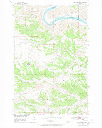
1954 Map of Baker Monument
USGS Topo · Published 1956About this map
The Missouri River winds through the northern reaches of this mid-century survey, defining the boundary between Fergus and Blaine counties. This rugged landscape was a focal point for infrastructure during the development of the Missouri River Basin, evidenced by the Powerplant and nearby Powerplant (Ruins) located along the riverbanks. The existence of a Ferry and a Gaging Sta near the Heller Sch suggests a period when river-based transit and resource monitoring were vital to the local economy.
Find a feature on this map
17 named features on this map. Tap any name to fly to it.
Don’t see what you’re looking for? This feature index may not catch every label — zoom into the map to look around manually.
Map Details
Editions of this 1954 Baker Monument Map
2 editions found
Other maps of this area

1943 · Landusky
USGS Topo · 1:125,000

1954 · Cow Island
USGS Topo · 1:24,000

1954 · Sturgeon Island
USGS Topo · 1:24,000

1954 · Grand Island
USGS Topo · 1:24,000

1954 · Lewistown
USGS Topo · 1:250,000

1959 · Lewistown
USGS Topo · 1:250,000
1971 · Shetland Divide
USGS Topo · 1:24,000

1984 · Zortman
USGS Topo · 1:100,000

1985 · Thompson Coulee
USGS Topo · 1:24,000
1985 · Mitchell Crossing
USGS Topo · 1:24,000