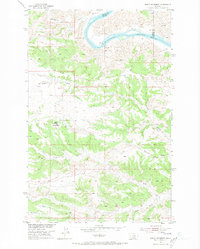
1954 Map of Baker Monument
USGS Topo · Published 1973About this map
The Missouri River winds through the northern reaches of this mid-century survey, marking the intersection of Fergus, Blaine, and Phillips counties. Along its banks, the remnants of early infrastructure are visible at the Powerplant (Ruins) and a nearby Gaging Sta. The landscape is dominated by complex drainage systems, including the branching Two Calf Creek and South Fork Two Calf Creek, which cut deep through the breaks south of the river. Evidence of local education and community organization appears at Heller Sch, serving the scattered homesteads of this prairie landscape. To the west, the prominent high point of Baker Monument stands as a significant local landmark, while Barnes Ridge provides a natural divide to the southeast. These features illustrate the sparse but deliberate settlement pattern typical of the Missouri River Basin during the early 1950s.
Find a feature on this map
14 named features on this map. Tap any name to fly to it.
Don’t see what you’re looking for? This feature index may not catch every label — zoom into the map to look around manually.
Map Details
Editions of this 1954 Baker Monument Map
2 editions found
Other maps of this area

1943 · Landusky
USGS Topo · 1:125,000

1954 · Cow Island
USGS Topo · 1:24,000

1954 · Baker Monument
USGS Topo · 1:24,000

1954 · Sturgeon Island
USGS Topo · 1:24,000

1954 · Grand Island
USGS Topo · 1:24,000

1954 · Lewistown
USGS Topo · 1:250,000

1959 · Lewistown
USGS Topo · 1:250,000
1971 · Shetland Divide
USGS Topo · 1:24,000

1984 · Zortman
USGS Topo · 1:100,000

1985 · Thompson Coulee
USGS Topo · 1:24,000