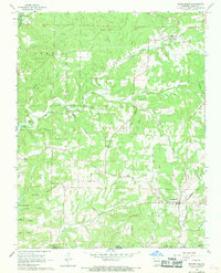
1968 Map of Bakersfield
USGS Topo · Published 1969About this map
Bakersfield and the surrounding Ozark hills of Missouri and Arkansas are documented here in the late 1960s, showing a landscape defined by deep hollows and creek systems. Small rural communities like Elijah are connected by winding routes, while the spiritual and social life of the area is anchored by landmarks such as Mineral Point Ch, Baptist Hill Ch, and Mt Pleasant Ch. This survey captures the borderlands between Ozark, Baxter, and Fulton counties, including the northern reaches of Norfork Lake and the Tecumseh Lookout Tower presiding over the timbered ridges.
Find a feature on this map
52 named features on this map. Tap any name to fly to it.
Don’t see what you’re looking for? This feature index may not catch every label — zoom into the map to look around manually.
Map Details
Editions of this 1968 Bakersfield Map
2 editions found
Other maps of this area

1890 · Mountain Home
USGS Topo · 1:125,000

1891 · Mountain Home
USGS Topo · 1:125,000

1894 · Mountain Home
USGS Topo · 1:125,000

1934 · Gainesville
USGS Topo · 1:48,000

1940 · Gainesville
USGS Topo · 1:62,500

1944 · Cureall
USGS Topo · 1:62,500

1945 · Harrison
USGS Topo · 1:250,000

1946 · Cureall
USGS Topo · 1:62,500

1949 · Harrison
USGS Topo · 1:250,000

1954 · Harrison
USGS Topo · 1:250,000