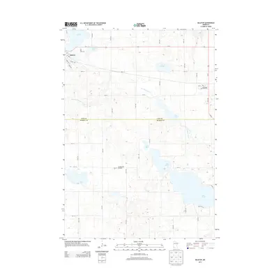
2013 Map of Balaton
USGS Topo · Published 2013About this map
Balaton and Garvin anchor this portion of the Coteau des Prairies in southwestern Minnesota. Situated along the boundary of Lyon and Murray counties, the landscape is defined by its glacial till and numerous water bodies, including Lake Yankton and the expansive Lake Sarah. The headwaters of the Des Moines River flow through the center of the sheet, illustrating the transition from local drainage to major river systems. Agricultural patterns are evident in the strict grid of rural roads like 120th St and 150th Ave that crisscross the region. Local landmarks like the East Bay Golf Course and small-town centers serve as focal points for the surrounding rural community. The concentration of lakes, such as Lake Maria and Spink Lake, highlights the importance of water resources to the region's recreational and agricultural identity.
Find a feature on this map
43 named features on this map. Tap any name to fly to it.
Don’t see what you’re looking for? This feature index may not catch every label — zoom into the map to look around manually.
Map Details
Editions of this 2013 Balaton Map
This is the sole edition of this map. No revisions or reprints were ever made.
Other maps of this area

1953 · New Ulm
USGS Topo · 1:250,000

1957 · New Ulm
USGS Topo · 1:250,000

1958 · New Ulm
USGS Topo · 1:250,000

1962 · Amiret
USGS Topo · 1:24,000

1963 · Russell
USGS Topo · 1:24,000

1963 · Marshall SE
USGS Topo · 1:24,000

1967 · New Ulm
USGS Topo · 1:250,000

1967 · Balaton
USGS Topo · 1:24,000
1967 · Balaton SW
USGS Topo · 1:24,000

1967 · Hadley
USGS Topo · 1:24,000