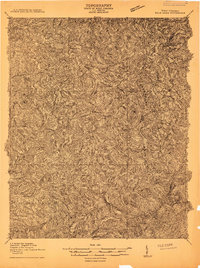
1910 Map of Bald Knob
USGS Topo · Published 1910About this map
Boone County and its neighboring territories of Raleigh and Logan are defined by a complex network of waterways and ridges in this 1910 survey. The drainage systems of the West Fork and Pond Fork converge to form the Coal River, a primary geographic artery through the district. This landscape is partitioned into significant civil divisions including Sherman, Washington, and Triadelphia, reflecting the political organization of the era. The terrain is dominated by the imposing Guyandot Mountain and the deep incisions of the Marsh Fork and Clear Fork. As an advance sheet, this map focuses heavily on the natural topography and political boundaries of the West Virginia coalfields before the intensive industrial development of later decades, providing a baseline for researchers studying the original landforms and early township lines of Logan and its surroundings.
Find a feature on this map
13 named features on this map. Tap any name to fly to it.
Don’t see what you’re looking for? This feature index may not catch every label — zoom into the map to look around manually.
Map Details
Editions of this 1910 Bald Knob Map
2 editions found

Other maps of this area

1891 · Oceana
USGS Topo · 1:125,000

1891 · Raleigh
USGS Topo · 1:125,000

1893 · Oceana
USGS Topo · 1:125,000

1897 · Kanawha Falls
USGS Topo · 1:125,000

1897 · Raleigh
USGS Topo · 1:125,000

1898 · Oceana
USGS Topo · 1:125,000

1899 · Charleston
USGS Topo · 1:125,000

1900 · Kanawha Falls
USGS Topo · 1:125,000

1901 · Kanawha Falls
USGS Topo · 1:125,000

1902 · Raleigh
USGS Topo · 1:125,000