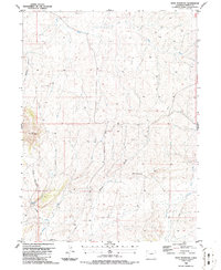
1986 Map of Bald Mountain
USGS Topo · Published 1986About this map
Bald Mountain dominates this portion of Moffat County, rising above a network of seasonal drainages and dry washes that define the high desert topography. This 1980s landscape is primarily defined by its hydrological features and infrastructure, including a prominent Pipeline and isolated Drill Hole locations that suggest early energy exploration in the region. Water sources were critical to the livestock operations here, as evidenced by the Corral and named springs such as Cutshaw Spring. The drainage pattern is complex, with Red Wash in the north and the Hardgrove Run system to the south, both of which cut through the arid soil near Lucas Hill. This map provides a clear record of the area's grazing and industrial footprint before late-20th-century developments changed the local land use.
Find a feature on this map
15 named features on this map. Tap any name to fly to it.
Don’t see what you’re looking for? This feature index may not catch every label — zoom into the map to look around manually.
Map Details
Editions of this 1986 Bald Mountain Map
This is the sole edition of this map. No revisions or reprints were ever made.
Other maps of this area

1916 · Craig
USGS Topo · 1:125,000

1954 · Vernal
USGS Topo · 1:250,000

1954 · Craig
USGS Topo · 1:250,000

1957 · Craig
USGS Topo · 1:250,000

1958 · Vernal
USGS Topo · 1:250,000

1958 · Craig
USGS Topo · 1:250,000

1958 · Maybell
USGS Topo · 1:62,500

1960 · Craig
USGS Topo · 1:250,000

1960 · Vernal
USGS Topo · 1:250,000

1962 · Craig
USGS Topo · 1:250,000