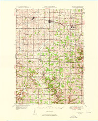
1949 Map of Baldwin
USGS Topo · Published 1949About this map
The Chicago and North Western railroad forms the backbone of development across these St. Croix and Pierce County townships, linking the established villages of Hammond, Baldwin, and Woodville. The landscape is defined by the headwaters of the Rush River and Kinnickinnic River, which carve through a dense network of dairy-era farmstead infrastructure. This 1940s landscape is exceptionally detailed in its rural social geography, recording dozens of local schoolhouses such as Birchdale Sch and Morton Corner Sch, alongside community anchors like Emmanuel Lutheran Ch and Happy Valley Ch. A notable geological landmark, Crystal Cave, appears near the border of Spring Lake and Rock Elm. The transition from the northern rail corridor to the southern settlements of Lawton and El Paso illustrates the local reliance on both the iron rail and the winding river valleys for commerce and transit before the expansion of the modern highway system.
Find a feature on this map
69 named features on this map. Tap any name to fly to it.
Don’t see what you’re looking for? This feature index may not catch every label — zoom into the map to look around manually.
Map Details
Editions of this 1949 Baldwin Map
2 editions found

Other maps of this area

1935 · Arkansaw
USGS Topo · 1:48,000

1940 · Maiden Rock
USGS Topo · 1:62,500

1941 · Arkansaw
USGS Topo · 1:62,500

1942 · Arkansaw
USGS Topo · 1:62,500

1944 · Red Wing
USGS Topo · 1:62,500

1946 · Knapp
USGS Topo · 1:62,500

1946 · River Falls
USGS Topo · 1:62,500

1948 · New Richmond
USGS Topo · 1:62,500

1948 · Downing
USGS Topo · 1:62,500

1949 · New Richmond
USGS Topo · 1:62,500