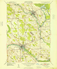
1948 Map of Baldwinsville
USGS Topo · Published 1948About this map
The Seneca River and Oneida River converge at Three Rivers to form the Oswego River, creating a complex inland waterway system defined by the modern Barge Canal. This 1948 survey by the U.S. Geological Survey captures Baldwinsville and Phoenix during a period of established industrial and maritime activity along these historic corridors. The landscape is marked by a network of rural schoolhouses, such as School No 14 and School No 11, and family-named cemeteries including Chase Cem and Rouse Cem. The Delaware Lackawanna and Western Road and New York Central Road parallel the waterways, illustrating the tight relationship between rail and river transit in Onondaga and Oswego counties. Large land tracts like Horseshoe Island and smaller features like Treasure Island punctuate the river bends, while the Golf Course south of Baldwinsville signals mid-century suburban development.
Find a feature on this map
44 named features on this map. Tap any name to fly to it.
Don’t see what you’re looking for? This feature index may not catch every label — zoom into the map to look around manually.
Map Details
Editions of this 1948 Baldwinsville Map
This is the sole edition of this map. No revisions or reprints were ever made.
Other maps of this area

1895 · Syracuse
USGS Topo · 1:62,500

1898 · Syracuse
USGS Topo · 1:62,500

1900 · Baldwinsville
USGS Topo · 1:62,500

1900 · Fulton
USGS Topo · 1:62,500

1905 · Mexico
USGS Topo · 1:62,500

1939 · Syracuse West
USGS Topo · 1:24,000

1940 · Brewerton
USGS Topo · 1:24,000

1943 · Jordan
USGS Topo · 1:31,680

1943 · Lysander
USGS Topo · 1:31,680

1943 · Brewerton
USGS Topo · 1:31,680