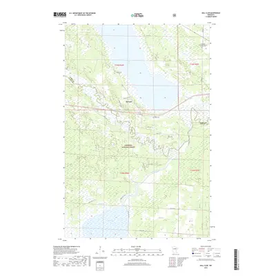
2019 Map of Ball Club
USGS Topo · Published 2019About this map
Chippewa National Forest encompasses much of this Northern Minnesota landscape, where the confluence of the Mississippi River and the Leech Lake River creates a complex network of wetlands and waterways. Near the northern shore of Ball Club Lake, the settlement of Ball Club serves as a local hub along the corridor between the Itasca County and Cass County border. The map reveals a high density of sites for genealogical research, including the Lindenwood - Independent Apostolic Lutheran Cem to the northeast and the Tibbets Cem overlooking the lake. Further south, the Saint Joseph Cem and Mary Donald Cem are situated within the wooded interior, connected by a network of forest routes like Forest Rte 2127. The watery terrain is defined by low-lying areas such as Mud Lake and the meandering path of Peggy Brook, illustrating the hydrologic character of this timbered region.
Find a feature on this map
32 named features on this map. Tap any name to fly to it.
Don’t see what you’re looking for? This feature index may not catch every label — zoom into the map to look around manually.
Map Details
Editions of this 2019 Ball Club Map
This is the sole edition of this map. No revisions or reprints were ever made.
Other maps of this area

1954 · Bemidji
USGS Topo · 1:250,000

1954 · Hibbing
USGS Topo · 1:250,000

1957 · Bemidji
USGS Topo · 1:250,000

1957 · Hibbing
USGS Topo · 1:250,000

1958 · Bemidji
USGS Topo · 1:250,000

1958 · Hibbing
USGS Topo · 1:250,000

1964 · Hibbing
USGS Topo · 1:250,000

1970 · Deer River NE
USGS Topo · 1:24,000
1970 · Deer River
USGS Topo · 1:24,000

1970 · Ball Club
USGS Topo · 1:24,000