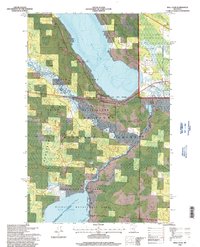
1996 Map of Ball Club
USGS Topo · Published 1998About this map
Ball Club Lake and the meandering upper reaches of the Mississippi River anchor this 1990s landscape, where the Leech Lake Indian Reservation meets the Chippewa National Forest. The settlement of Ball Club serves as the central point of interest, located along the western shore of the lake. The map reveals a high concentration of wetlands and conservation lands, including the Mud Lake Wildlife Management Area and the Snake Brook Impoundment. Local history is captured through markers like the Tibbetts Cem, a smaller unnamed Cemetery, and the Apostolic Church. Industrial footprints are visible through the Oil Pipeline and Gas Pipeline corridors that cut across the northern terrain, alongside a notable Gravel Pit and the rugged Morse area. This survey documents the complex water systems of Mud Goose Lake and Mud Lake before they exit the quadrangle boundaries.
Find a feature on this map
19 named features on this map. Tap any name to fly to it.
Don’t see what you’re looking for? This feature index may not catch every label — zoom into the map to look around manually.
Map Details
Editions of this 1996 Ball Club Map
This is the sole edition of this map. No revisions or reprints were ever made.
Other maps of this area

1954 · Bemidji
USGS Topo · 1:250,000

1954 · Hibbing
USGS Topo · 1:250,000

1957 · Bemidji
USGS Topo · 1:250,000

1957 · Hibbing
USGS Topo · 1:250,000

1958 · Bemidji
USGS Topo · 1:250,000

1958 · Hibbing
USGS Topo · 1:250,000

1964 · Hibbing
USGS Topo · 1:250,000

1970 · Deer River NE
USGS Topo · 1:24,000
1970 · Deer River
USGS Topo · 1:24,000

1970 · Ball Club
USGS Topo · 1:24,000