
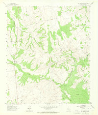
1963 Map of Ballinger Ranch
USGS Topo · Published 1964About this map
Ballinger Ranch and Shafer Ranch anchor this landscape in Glasscock County, representative of the cattle ranching operations that defined the region in the early 1960s. The terrain is deeply inscribed by a drainage network comprising Polecat Creek, Middle Fork, and West Fork, all flowing through the undulating West Texas plains. Evidence of infrastructure is limited but significant, with a major Pipeline cutting across the central topography, signaling the energy sector's growing footprint alongside traditional ranching. These ranch outposts, paired with local Gravel Pit extractions, illustrate a rural economy reliant on both natural resources and land management in an arid environment before more intensive development altered the local character.
Find a feature on this map
8 named features on this map. Tap any name to fly to it.
Don’t see what you’re looking for? This feature index may not catch every label — zoom into the map to look around manually.
Map Details
Editions of this 1963 Ballinger Ranch Map
2 editions found
Other maps of this area

1941 · Morita
USGS Topo · 1:62,500

1941 · Big Spring South
USGS Topo · 1:62,500

1942 · Big Spring South
USGS Topo · 1:62,500

1949 · Morita
USGS Topo · 1:62,500

1954 · Big Spring
USGS Topo · 1:250,000

1954 · San Angelo
USGS Topo · 1:250,000

1958 · San Angelo
USGS Topo · 1:250,000

1958 · Big Spring
USGS Topo · 1:250,000

1963 · Currie Reservoir
USGS Topo · 1:24,000

1963 · Garden City NE
USGS Topo · 1:24,000