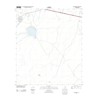
2012 Map of Balmorhea
USGS Topo · Published 2012About this map
Balmorhea serves as the focal point of this arid West Texas landscape, where a sophisticated network of human-made waterways dictates the life of the desert. The Reeves County Water Improvement Canal and the Madera Diversion Canal channel water toward the significant Balmorhea Lake, illustrating the region's reliance on managed irrigation. To the northwest, Sandia Springs provides a natural contrast to these engineered features. Beyond the town grid and its cemetery at Brogade Cem, the terrain rises toward the Saddle Back Mountains and Point Canyon in the south. This survey documents a ranching and agricultural economy defined by isolated landmarks like the High Windmill and numerous drainage features such as Kountz Draw and Toyah Cr.
Find a feature on this map
39 named features on this map. Tap any name to fly to it.
Don’t see what you’re looking for? This feature index may not catch every label — zoom into the map to look around manually.
Map Details
Editions of this 2012 Balmorhea Map
This is the sole edition of this map. No revisions or reprints were ever made.
Other maps of this area

1894 · Fort Davis
USGS Topo · 1:125,000

1897 · Fort Davis
USGS Topo · 1:125,000

1921 · Toyah
USGS Topo · 1:125,000

1954 · Pecos
USGS Topo · 1:250,000

1954 · Fort Stockton
USGS Topo · 1:250,000

1955 · Saragosa
USGS Topo · 1:62,500

1957 · Pecos
USGS Topo · 1:250,000

1958 · Fort Stockton
USGS Topo · 1:250,000
1970 · Verhalen South
USGS Topo · 1:24,000
1970 · Saragosa
USGS Topo · 1:24,000