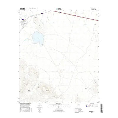
2016 Map of Balmorhea
USGS Topo · Published 2016About this map
Sandia Springs and the headwaters of Toyah Creek anchor the northern reaches of this Trans-Pecos landscape, where a sophisticated network of irrigation infrastructure manages the region's limited water. The town of Balmorhea sits at the nexus of these systems, surrounded by the Main Canal, Madera Diversion Canal, and Inlet Feeder Canal which direct flow into Balmorhea Lake. This water management system is essential for the local agriculture visible in the grid of county roads northeast of the settlement.
Find a feature on this map
41 named features on this map. Tap any name to fly to it.
Don’t see what you’re looking for? This feature index may not catch every label — zoom into the map to look around manually.
Map Details
Editions of this 2016 Balmorhea Map
This is the sole edition of this map. No revisions or reprints were ever made.
Other maps of this area

1894 · Fort Davis
USGS Topo · 1:125,000

1897 · Fort Davis
USGS Topo · 1:125,000

1921 · Toyah
USGS Topo · 1:125,000

1954 · Pecos
USGS Topo · 1:250,000

1954 · Fort Stockton
USGS Topo · 1:250,000

1955 · Saragosa
USGS Topo · 1:62,500

1957 · Pecos
USGS Topo · 1:250,000

1958 · Fort Stockton
USGS Topo · 1:250,000
1970 · Verhalen South
USGS Topo · 1:24,000
1970 · Saragosa
USGS Topo · 1:24,000