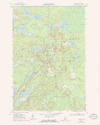
1970 Map of Balsam
USGS Topo · Published 1990About this map
Savanna Portage State Park and the surrounding Savanna State Forest dominate this landscape, reflecting a region defined by its glacial hydrology and historic transit routes. The presence of the Chapel in the Pines near Shumway Lake marks a point of community and spiritual gathering within the preserved woods. A dense network of Snowmobile Trails and Winter Trails crisscross the terrain, highlighting the area's importance for cold-weather navigation and recreation in the 1970s.
Find a feature on this map
37 named features on this map. Tap any name to fly to it.
Don’t see what you’re looking for? This feature index may not catch every label — zoom into the map to look around manually.
Map Details
Editions of this 1970 Balsam Map
2 editions found
Other maps of this area

1953 · Duluth
USGS Topo · 1:250,000

1958 · Duluth
USGS Topo · 1:250,000

1969 · Island
USGS Topo · 1:24,000

1970 · Tamarack
USGS Topo · 1:24,000

1970 · Little Prairie Lake
USGS Topo · 1:24,000
1970 · Vanduse Lake
USGS Topo · 1:24,000

1970 · Balsam
USGS Topo · 1:24,000
1970 · Ball Bluff
USGS Topo · 1:24,000

1970 · Libby
USGS Topo · 1:24,000

1970 · Wright
USGS Topo · 1:24,000