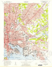
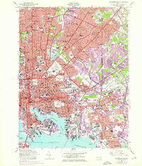
1953 Map of Baltimore East
USGS Topo · Published 1957About this map
The dense industrial and residential fabric of East Baltimore comes into sharp focus during the mid-1950s, showing a city deeply integrated with its maritime and rail infrastructure. At the heart of the harbor, Northwest Harbor is flanked by massive logistics hubs like the Canton Yard and the Riverside Yard, illustrating the era's heavy reliance on the Pennsylvania Railroad and Baltimore and Ohio Railroad. Urban life is anchored by significant institutional landmarks, from the sprawling campus of Johns Hopkins University and the Maryland Sch for the Blind to the historic grounds of Greenmount Cemetery.
Find a feature on this map
165 named features on this map. Tap any name to fly to it.
Don’t see what you’re looking for? This feature index may not catch every label — zoom into the map to look around manually.
Map Details
Editions of this 1953 Baltimore East Map
5 editions found
Other maps of this area

1893 · North Point
USGS Topo · 1:62,500

1893 · Gunpowder
USGS Topo · 1:62,500

1894 · Baltimore
USGS Topo · 1:62,500

1894 · Relay
USGS Topo · 1:62,500

1898 · Tolchester
USGS Topo · 1:125,000

1899 · Baltimore
USGS Topo · 1:62,500

1901 · Gunpowder
USGS Topo · 1:62,500

1903 · Tolchester
USGS Topo · 1:125,000

1904 · Baltimore
USGS Topo · 1:62,500

1904 · North Point
USGS Topo · 1:62,500