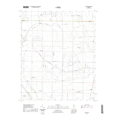
2020 Map of Baltzer
USGS Topo · Published 2020About this map
Big Sunflower River winds along the western edge of this Mississippi Delta landscape, defining a region where the water and soil have long shaped local life. The agricultural grid is densely overlaid with named roads and local landmarks, including the settlements of Baltzer, Lombardy, and Fitzhugh. This area is marked by numerous family and community burial sites such as Mount Olive Cem, Saint Paul Cem, and Shady Grove Cem, which serve as vital anchors for genealogical research. The drainage patterns of Black Bayou and Bear Bayou intersect with an extensive network of rural routes, including many numbered Parchman roads. This contemporary survey captures the enduring rural character of the Coahoma and Sunflower county line, where large-scale farming and small community hubs like Pilgrim Rest Cem remain central to the geography.
Find a feature on this map
49 named features on this map. Tap any name to fly to it.
Don’t see what you’re looking for? This feature index may not catch every label — zoom into the map to look around manually.
Map Details
Editions of this 2020 Baltzer Map
This is the sole edition of this map. No revisions or reprints were ever made.
Other maps of this area

1931 · Sumner
USGS Topo · 1:48,000

1931 · Drew
USGS Topo · 1:48,000

1932 · Tutwiler
USGS Topo · 1:48,000

1935 · Clarksdale
USGS Topo · 1:62,500

1935 · Sumner
USGS Topo · 1:62,500

1935 · Tutwiler
USGS Topo · 1:62,500

1935 · Mound Bayou
USGS Topo · 1:62,500

1939 · Sumner
USGS Topo · 1:62,500

1939 · Tutwiler
USGS Topo · 1:62,500

1939 · Clarksdale
USGS Topo · 1:62,500