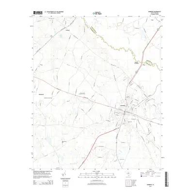
2014 Map of Bamberg
USGS Topo · Published 2014About this map
The South Fork Edisto River forms a winding natural boundary between Bamberg and Orangeburg counties, anchoring a landscape defined by significant watercourse networks and small rural hubs. The city of Bamberg sits at a crossroads of state and federal routes, including the Heritage Hwy, while the neighboring settlement of Denmark and the smaller community of Finland highlight the region's historic rail-and-road development. Local genealogy is supported by several mapped burial grounds such as Log Bridge Cem and Bamberg County Memory Gardens. The topography rises slightly at Quartemans Hill, but the area is primarily shaped by its drainage basins, including Lemon Cr, Snake Swamp, and Grapevine Br. These waterways feed into the river system near landmarks like Bobcat Landing and Edisto Pond, reflecting the long-standing importance of the river to local transit and recreation.
Find a feature on this map
111 named features on this map. Tap any name to fly to it.
Don’t see what you’re looking for? This feature index may not catch every label — zoom into the map to look around manually.
Map Details
Editions of this 2014 Bamberg Map
This is the sole edition of this map. No revisions or reprints were ever made.
Other maps of this area

1919 · Olar
USGS Topo · 1:62,500

1919 · Bamberg
USGS Topo · 1:48,000

1919 · Lodge
USGS Topo · 1:62,500

1920 · Lodge
USGS Topo · 1:48,000

1920 · Bamberg
USGS Topo · 1:62,500

1920 · Orangeburg
USGS Topo · 1:48,000

1921 · Orangeburg
USGS Topo · 1:62,500

1921 · Lodge
USGS Topo · 1:62,500

1943 · Olar
USGS Topo · 1:62,500

1943 · Lodge
USGS Topo · 1:62,500