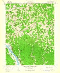
1958 Map of Bancroft
USGS Topo · Published 1960About this map
The West Virginia landscape near the end of the 1950s is defined by the high, winding spine of Sandhill Ridge and the deeply dissected hills that characterize this portion of the state. Settlement patterns remain sparse across the upland terrain, with small, localized places like Extra marking the map alongside the natural drainage patterns of the region. This 1958 field-checked survey captures the rural character of the area just before significant modernization, showing a topography shaped by steep ridges and narrow hollows. The layout of these physical features reveals how geography dictated the early development and transit routes within this part of West Virginia, preserved here in precise detail by the U.S. Geological Survey.
Find a feature on this map
2 named features on this map. Tap any name to fly to it.
Don’t see what you’re looking for? This feature index may not catch every label — zoom into the map to look around manually.
Map Details
Editions of this 1958 Bancroft Map
2 editions found
Other maps of this area

1899 · Charleston
USGS Topo · 1:125,000

1906 · Kenna
USGS Topo · 1:62,500

1906 · Winfield
USGS Topo · 1:62,500

1907 · Kenna
USGS Topo · 1:62,500

1908 · Winfield
USGS Topo · 1:62,500

1909 · Charleston
USGS Topo · 1:62,500

1909 · Saint Albans
USGS Topo · 1:62,500

1931 · Saint Albans
USGS Topo · 1:62,500

1931 · Charleston
USGS Topo · 1:62,500

1933 · Saint Albans
USGS Topo · 1:62,500