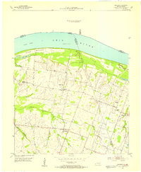
1954 Map of Bandana
USGS Topo · Published 1955About this map
Bandana and the uniquely named Monkeys Eyebrow anchor this mid-century survey of the riverlands along the Ohio River. The landscape is defined by the transition from the fertile Oscar Bottoms and the complex of wetlands including Colvin Lake and Little Colvin Lake to the higher ground of Ballard and McCracken counties. The rural character of the area is evidenced by a dense network of country institutions such as Providence Ch, Pleasant Valley Ch, and Ragland Sch.
Find a feature on this map
30 named features on this map. Tap any name to fly to it.
Don’t see what you’re looking for? This feature index may not catch every label — zoom into the map to look around manually.
Map Details
Editions of this 1954 Bandana Map
This is the sole edition of this map. No revisions or reprints were ever made.
Other maps of this area

1918 · Vienna
USGS Topo · 1:62,500

1919 · Vienna
USGS Topo · 1:62,500

1920 · Dongola
USGS Topo · 1:62,500

1923 · Dongola
USGS Topo · 1:62,500

1928 · La Center
USGS Topo · 1:62,500

1931 · Cairo
USGS Topo · 1:62,500

1932 · La Center
USGS Topo · 1:62,500

1933 · Cairo
USGS Topo · 1:62,500

1939 · Cairo
USGS Topo · 1:62,500

1942 · Vienna
USGS Topo · 1:62,500