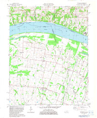
1982 Map of Bandana
USGS Topo · Published 1983About this map
The Ohio River dominates the northern border of this West Kentucky landscape, where the shifting river currents meet the low-lying Oscar Bottoms. This 1982 survey details a rural network of small settlements and family landmarks, including the uniquely named Monkeys Eyebrow and Needmore. The terrain is defined by a complex system of drainage creeks like Clanton Creek and Hawley Creek that flow through the agricultural heart of Ballard County.
Find a feature on this map
51 named features on this map. Tap any name to fly to it.
Don’t see what you’re looking for? This feature index may not catch every label — zoom into the map to look around manually.
Map Details
Editions of this 1982 Bandana Map
This is the sole edition of this map. No revisions or reprints were ever made.
Other maps of this area

1918 · Vienna
USGS Topo · 1:62,500

1919 · Vienna
USGS Topo · 1:62,500

1920 · Dongola
USGS Topo · 1:62,500

1923 · Dongola
USGS Topo · 1:62,500

1928 · La Center
USGS Topo · 1:62,500

1931 · Cairo
USGS Topo · 1:62,500

1932 · La Center
USGS Topo · 1:62,500

1933 · Cairo
USGS Topo · 1:62,500

1939 · Cairo
USGS Topo · 1:62,500

1942 · Vienna
USGS Topo · 1:62,500