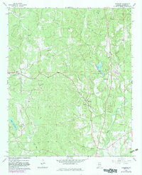
1967 Map of Bankston
USGS Topo · Published 1983About this map
The Southern railroad corridor dictates the settlement patterns of this Fayette County landscape, connecting the small communities of Stough, Bankston, and Cleveland. This rural Alabama territory is defined by a dense network of country churches, including Oak Grove Ch, Bethel Ch, and Philadelphia Ch, which served as the social anchors for dispersed farming families. The topography is deeply carved by water, with the North River and its many tributaries like Deadwater Creek and Clear Creek winding through the terrain.
Find a feature on this map
31 named features on this map. Tap any name to fly to it.
Don’t see what you’re looking for? This feature index may not catch every label — zoom into the map to look around manually.
Map Details
Editions of this 1967 Bankston Map
2 editions found
Other maps of this area

1953 · Birmingham
USGS Topo · 1:250,000

1956 · Birmingham
USGS Topo · 1:250,000

1957 · Birmingham
USGS Topo · 1:250,000

1967 · Bankston
USGS Topo · 1:24,000

1967 · Winfield SE
USGS Topo · 1:24,000

1967 · Newtonville
USGS Topo · 1:24,000

1967 · Hubbertville
USGS Topo · 1:24,000
1967 · Berry
USGS Topo · 1:24,000

1967 · Fayette
USGS Topo · 1:24,000
1967 · New Lexington
USGS Topo · 1:24,000