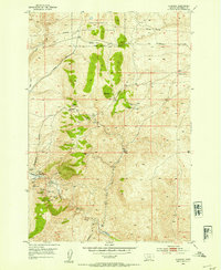
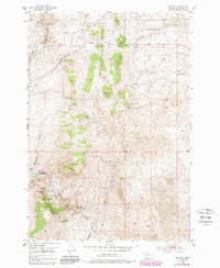
1952 Map of Bannack
USGS Topo · Published 1954About this map
Bannack (First Territorial Capital) remains the focal point of this 1952 topographic study, showing the town at the intersection of Grasshopper Creek and Hangmans Gulch. While most workings are noted as inactive by this era, the landscape is heavily marked by its placer and lode mining heritage, featuring names like the Hope Placer Mine and Hendricks Lode Mine. Notable exceptions to the dormancy include the New Departure Mine and Blue Dot Mine, both indicated as active operations east of Road Agents Rock. To the north, the Bannack Road winds through Badger Pass within the Beaverhead National Forest, following the high-elevation terrain where the Taylor Mine sits near the headwaters of Taylor Creek. The presence of the local Cemetery and multiple springs like McDowell Spring provides essential details for genealogists tracing early Montana mining families.
Find a feature on this map
37 named features on this map. Tap any name to fly to it.
Don’t see what you’re looking for? This feature index may not catch every label — zoom into the map to look around manually.
Map Details
Editions of this 1952 Bannack Map
6 editions found
Other maps of this area

1893 · Dillon
USGS Topo · 1:250,000

1952 · Argenta
USGS Topo · 1:24,000

1952 · Bannack
USGS Topo · 1:24,000

1952 · Burns Mountain
USGS Topo · 1:24,000

1952 · Eli Spring
USGS Topo · 1:24,000

1952 · Dalys
USGS Topo · 1:24,000

1952 · Ermont
USGS Topo · 1:24,000

1955 · Dillon
USGS Topo · 1:250,000

1957 · Dillon
USGS Topo · 1:250,000

1958 · Dillon
USGS Topo · 1:250,000