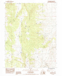
1984 Map of Banner Ridge
USGS Topo · Published 1984About this map
The Benton Range and its defining Banner Ridge dominate this mid-1980s survey, revealing a landscape heavily marked by mineral exploration. Within the Inyo National Forest, the map identifies numerous mining operations including the Gold Crown Mine, Black Rock Mine, and the Banner Mine (Tunnels). These sites are clustered along the high ground and within the steep drainages of Wildrose Canyon and Chidago Canyon, suggesting a period of significant geological interest in the high desert of Mono County.
Find a feature on this map
28 named features on this map. Tap any name to fly to it.
Don’t see what you’re looking for? This feature index may not catch every label — zoom into the map to look around manually.
Map Details
Editions of this 1984 Banner Ridge Map
2 editions found
Other maps of this area

1914 · Mt. Morrison
USGS Topo · 1:125,000

1917 · White Mountain
USGS Topo · 1:125,000

1947 · Mariposa
USGS Topo · 1:250,000

1948 · Mariposa
USGS Topo · 1:250,000

1953 · Casa Diablo Mtn
USGS Topo · 1:62,500

1957 · Mariposa
USGS Topo · 1:250,000

1962 · Benton
USGS Topo · 1:62,500

1962 · Glass Mountain
USGS Topo · 1:62,500

1962 · White Mtn. Peak
USGS Topo · 1:62,500

1963 · Mariposa
USGS Topo · 1:250,000