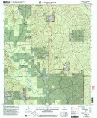
2000 Map of Barbara
USGS Topo · Published 2003About this map
De Soto National Forest dominates the landscape in this turn-of-the-century survey, where the winding course of Black Creek creates a complex network of sloughs and oxbows like Horseshoe Lake and Long Lake. The area reflects a deep-rooted rural settlement pattern, evidenced by numerous family burying grounds including Cochran Cem, Fairley Cem, and Cooper Cem. A significant portion of the eastern terrain is designated as a Special Military Area, illustrating the dual use of these public lands for both national defense and recreation. Recreational access is anchored by the Fairley Bridge Boat Landing and Picnic Area and the Black Creek Hiking Trail, which follows the river's northern bank through the forest. Small community hubs are centered around St Luke Ch and Mars Hill Ch, serving the dispersed population near Barbara and Batt Place.
Find a feature on this map
36 named features on this map. Tap any name to fly to it.
Don’t see what you’re looking for? This feature index may not catch every label — zoom into the map to look around manually.
Map Details
Editions of this 2000 Barbara Map
This is the sole edition of this map. No revisions or reprints were ever made.
Other maps of this area

1947 · Beaumont
USGS Topo · 1:62,500

1947 · Wiggins
USGS Topo · 1:62,500

1947 · New Augusta
USGS Topo · 1:62,500

1947 · Benndale
USGS Topo · 1:62,500

1949 · Wiggins
USGS Topo · 1:62,500

1949 · Beaumont
USGS Topo · 1:62,500

1949 · New Augusta
USGS Topo · 1:62,500

1949 · Benndale
USGS Topo · 1:62,500

1953 · Hattiesburg
USGS Topo · 1:250,000

1953 · Mobile
USGS Topo · 1:250,000