1957 Map of Barboursville
USGS Topo · Published 1965About this map
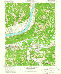
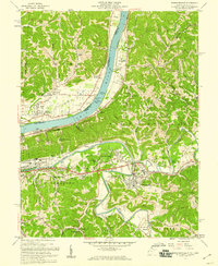
The Ohio River valley serves as a bustling corridor of transportation and settlement in this late 1950s survey of the tri-state border region. At the center of the sheet, the Guyandotte River winds northward to join the Ohio, marking a landscape defined by its river-and-rail economy. The presence of Lock No 27 on the Ohio and the crossing lines of the Baltimore and Ohio and Chesapeake and Ohio railroads highlight the industrial significance of the area. On the West Virginia side, the town of Barboursville sits at the confluence of the Guyandotte and Mud River, while residential expansion is evident along East Pea Ridge and West Pea Ridge. To the north, the Ohio side features established communities like Proctorville and Rome, anchored by local landmarks such as the County Fairgrounds and Fairland High Sch. This map provides a detailed view of the region before significant interstate highway development, capturing a web of rural schools and churches including Susie Chapel and Submissive Ch.
Find a feature on this map
63 named features on this map. Tap any name to fly to it.
Don’t see what you’re looking for? This feature index may not catch every label — zoom into the map to look around manually.
Map Details
Editions of this 1957 Barboursville Map
2 editions found
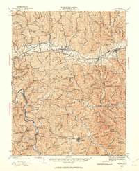
Other maps of this area

1892 · Huntington
USGS Topo · 1:125,000

1898 · Huntington
USGS Topo · 1:125,000

1901 · Guyandot
USGS Topo · 1:62,500

1902 · Guyandot
USGS Topo · 1:62,500

1902 · Milton
USGS Topo · 1:62,500

1906 · Athalia
USGS Topo · 1:62,500

1906 · Glenwood
USGS Topo · 1:62,500

1908 · Athalia
USGS Topo · 1:62,500

1908 · Glenwood
USGS Topo · 1:62,500
1931 · Milton
USGS Topo · 1:62,500