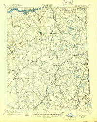
1905 Map of Barclay
USGS Topo · Published 1944About this map
Agricultural life along the Maryland-Delaware border centers on small railroad depots and river landings in this early twentieth-century landscape. The Philadelphia Baltimore and Washington R R and the Delaware and Chesapeake R R create a vital transportation corridor through Barclay and Sudlersville, connecting inland farms to regional markets. To the north, the Chester River serves as a critical artery with active points of commerce like Travilla Whf, Deer Landing, and Crumpton.
Find a feature on this map
66 named features on this map. Tap any name to fly to it.
Don’t see what you’re looking for? This feature index may not catch every label — zoom into the map to look around manually.
Map Details
Editions of this 1905 Barclay Map
3 editions found
Other maps of this area

1898 · Choptank
USGS Topo · 1:125,000

1898 · Tolchester
USGS Topo · 1:125,000

1899 · Dover
USGS Topo · 1:125,000

1900 · Cecilton
USGS Topo · 1:62,500

1900 · Betterton
USGS Topo · 1:62,500

1901 · Chestertown
USGS Topo · 1:62,500

1903 · Tolchester
USGS Topo · 1:125,000

1904 · St. Michaels
USGS Topo · 1:62,500

1905 · Denton
USGS Topo · 1:62,500

1905 · Barclay
USGS Topo · 1:62,500