
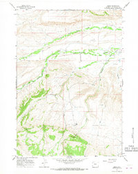
2017 Map of Bargee
USGS Topo · Published 2017About this map
The Owl Creek Mountains dominate this high-elevation landscape along the border of Fremont and Hot Springs counties. This terrain is defined by its seasonal water sources and specialized access routes, including Blondy Pass and the drainage of Sagwup Draw. Remote roadways such as Mail Camp Rd, Stagner Rd, and Shotgun Butte Rd provide the primary infrastructure through the varying elevations of the Wind River Basin. Local ranching and water management are evident in the placement of Madden Reservoir and Bargee Reservoir. The presence of Warm Springs and several named creeks, such as Holland Cr and the descriptively named McKee Grave Cr, suggests a landscape shaped by early surveyors and cattlemen who relied on these specific points for navigation and survival in the Wyoming interior.
Find a feature on this map
24 named features on this map. Tap any name to fly to it.
Don’t see what you’re looking for? This feature index may not catch every label — zoom into the map to look around manually.
Map Details
Editions of this 2017 Bargee Map
This is the sole edition of this map. No revisions or reprints were ever made.
Other maps of this area

1950 · Shotgun Butte
USGS Topo · 1:24,000

1951 · Eagle Point
USGS Topo · 1:24,000

1951 · Maverick Spring
USGS Topo · 1:24,000

1952 · Antelope Ridge
USGS Topo · 1:24,000

1952 · Sheep Ridge
USGS Topo · 1:24,000

1952 · Bargee
USGS Topo · 1:24,000

1955 · Thermopolis
USGS Topo · 1:250,000

1958 · Thermopolis
USGS Topo · 1:250,000

1962 · Thermopolis
USGS Topo · 1:250,000
1965 · Embar
USGS Topo · 1:24,000