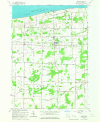
1965 Map of Barker
USGS Topo · Published 1967About this map
Lake Ontario borders the northern edge of this Niagara County landscape, where the shoreline is defined by Camp Kenan, the Sunset Memorial Tabernacle, and a nearby Filtration Plant. The village of Barker serves as the central hub, situated along the New York Central railroad line. This mid-1960s survey documents a transition in local infrastructure, noting several Industrial Waste Ponds just east of the village and the unique Barker Central Sch Airport located adjacent to the Barker Central Sch.
Find a feature on this map
45 named features on this map. Tap any name to fly to it.
Don’t see what you’re looking for? This feature index may not catch every label — zoom into the map to look around manually.
Map Details
Editions of this 1965 Barker Map
This is the sole edition of this map. No revisions or reprints were ever made.
Other maps of this area

1897 · Olcott
USGS Topo · 1:62,500

1897 · Medina
USGS Topo · 1:62,500

1897 · Lockport
USGS Topo · 1:62,500

1897 · Ridgeway
USGS Topo · 1:62,500

1899 · Niagara
USGS Topo · 1:125,000

1902 · Lockport
USGS Topo · 1:62,500

1905 · Lockport
USGS Topo · 1:62,500

1948 · Lockport
USGS Topo · 1:62,500

1948 · Olcott
USGS Topo · 1:62,500
1949 · Barker
USGS Topo · 1:24,000