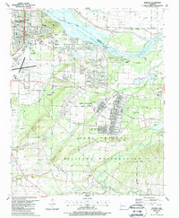
1987 Map of Barling
USGS Topo · Published 1988About this map
The Fort Chaffee Military Reservation dominates the southern landscape of this 1980s Arkansas survey, characterized by its extensive network of named boulevards, athletic fields, and post headquarters. To the north, the Arkansas River and the waters of Ozark Lake define the boundary between Sebastian and Crawford counties. The suburban growth of Fort Smith and Barling is evident through dense residential street grids and institutional landmarks like the St Edward Mercy Medical Center and Chaffin Jr High Sch. Genealogists will find a significant concentration of burial grounds, including the Steep Hill Cem, Laura A Nolan Cem, and Wisley Cem. The industrial footprint of the region is marked by numerous Gas Wells and Shale Pits, while an Old RR Grade cutting across Donahoa Ridge points to the area's earlier transportation history.
Find a feature on this map
52 named features on this map. Tap any name to fly to it.
Don’t see what you’re looking for? This feature index may not catch every label — zoom into the map to look around manually.
Map Details
Editions of this 1987 Barling Map
2 editions found
Other maps of this area

1879 · Fort Smith
USGS Topo · 1:62,500

1887 · Van Buren
USGS Topo · 1:62,500

1887 · Greenwood
USGS Topo · 1:62,500

1890 · Fort Smith
USGS Topo · 1:125,000

1906 · Lavaca
USGS Topo · 1:62,500

1906 · Barber
USGS Topo · 1:62,500

1943 · Fort Smith
USGS Topo · 1:125,000

1946 · Fort Smith
USGS Topo · 1:250,000

1947 · Lavaca
USGS Topo · 1:62,500

1947 · Van Buren
USGS Topo · 1:62,500