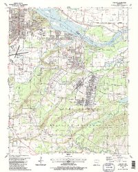
1987 Map of Barling
USGS Topo · Published 1988About this map
Fort Chaffee Military Reservation dominates the southern landscape of this 1980s survey, defined by a dense grid of infrastructure including Fort Smith Boulevard and Chaffee Boulevard. The surrounding area shows the transition from the urban reach of Fort Smith to established residential communities like Barling and Central City. Local genealogy is well-documented through numerous family and community burial sites, from the Laura A Nolan Cem and Wisley Cem in the east to McAllister Cem near the riverbanks.
Find a feature on this map
59 named features on this map. Tap any name to fly to it.
Don’t see what you’re looking for? This feature index may not catch every label — zoom into the map to look around manually.
Map Details
Editions of this 1987 Barling Map
2 editions found
Other maps of this area

1879 · Fort Smith
USGS Topo · 1:62,500

1887 · Van Buren
USGS Topo · 1:62,500

1887 · Greenwood
USGS Topo · 1:62,500

1890 · Fort Smith
USGS Topo · 1:125,000

1906 · Lavaca
USGS Topo · 1:62,500

1906 · Barber
USGS Topo · 1:62,500

1943 · Fort Smith
USGS Topo · 1:125,000

1946 · Fort Smith
USGS Topo · 1:250,000

1947 · Lavaca
USGS Topo · 1:62,500

1947 · Van Buren
USGS Topo · 1:62,500