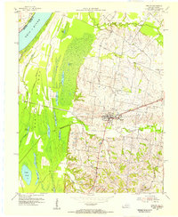
1954 Map of Barlow
USGS Topo · Published 1955About this map
The Ohio River dominates the western edge of this mid-century survey, creating a complex hydrologic landscape defined by the expansive Barlow Bottoms. This lowland area is a dense network of sloughs and lakes, including Swan Pond, Fish Lake, and Honey Lake Slough, which separate the mainland from Cache Island. The landscape transitions sharply from these alluvial bottomlands to the interior uplands where the town of Barlow serves as a local hub. The town is oriented along the Illinois Central Railroad Grade, which cuts west toward the river through the surrounding farmland. Genealogists will find a well-distributed network of rural markers, from the Old Hazelwood Cem to active country congregations like Ohio Valley Ch and Bethel Ch, illustrating the established social fabric of Ballard County during the early 1950s.
Find a feature on this map
38 named features on this map. Tap any name to fly to it.
Don’t see what you’re looking for? This feature index may not catch every label — zoom into the map to look around manually.
Map Details
Editions of this 1954 Barlow Map
This is the sole edition of this map. No revisions or reprints were ever made.
Other maps of this area

1928 · La Center
USGS Topo · 1:62,500

1931 · Cairo
USGS Topo · 1:62,500

1932 · La Center
USGS Topo · 1:62,500

1933 · Cairo
USGS Topo · 1:62,500

1939 · Wickliffe
USGS Topo · 1:62,500

1939 · Cairo
USGS Topo · 1:62,500

1949 · Paducah
USGS Topo · 1:250,000

1950 · Paducah
USGS Topo · 1:250,000

1951 · Blandville
USGS Topo · 1:24,000

1951 · Wickliffe
USGS Topo · 1:24,000