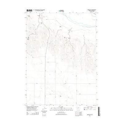
2014 Map of Barn Butte
USGS Topo · Published 2014About this map
Barn Butte and McCuligan Butte anchor this corner of the Nebraska Panhandle, rising above a landscape of deep canyons and seasonal drainages. The North Platte River flows through the northern reaches of the quadrangle, accompanied by the Midland Overland Canal and Lost Cr. This 2014 survey reveals a region defined by its traditional rangeland use, where a network of county roads like Road 181 and Ne 27 navigate the complex topography. Significant landforms such as Eagles Cliff, Swede Canyon, and the southern Ash Hollow reflect the area's geological character. The map illustrates how human infrastructure, including the Road 52 and Road 40 corridors, adapts to the natural draws of Wild Horse Canyon and Onstot Canyon, maintaining connectivity across this sparsely populated section of Garden County.
Find a feature on this map
24 named features on this map. Tap any name to fly to it.
Don’t see what you’re looking for? This feature index may not catch every label — zoom into the map to look around manually.
Map Details
Editions of this 2014 Barn Butte Map
This is the sole edition of this map. No revisions or reprints were ever made.
Other maps of this area

1900 · Chappell
USGS Topo · 1:125,000

1954 · Scottsbluff
USGS Topo · 1:250,000

1958 · Scottsbluff
USGS Topo · 1:250,000
1971 · Twin Buttes
USGS Topo · 1:24,000

1971 · Barn Butte
USGS Topo · 1:24,000

1971 · Chappell NE
USGS Topo · 1:24,000

1971 · Oshkosh SW
USGS Topo · 1:24,000

1971 · Coumbe Bluff
USGS Topo · 1:24,000
1971 · Lewellen
USGS Topo · 1:24,000

1971 · Chappell NW
USGS Topo · 1:24,000