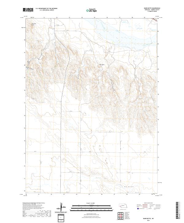
2021 Map of Barn Butte
USGS Topo · Published 2021About this map
The North Platte River defines the northern edge of this Garden County landscape, where it is joined by the braided channels of Lost Creek. This 2021 survey illustrates a deeply dissected terrain characterized by a series of prominent landmarks including Barn Butte and McCuligan Butte. The southern portion of the quadrangle is marked by Ash Hollow, an area of historical significance for travelers along the river corridor. The map details a complex network of local routes, such as RD 181 and RD 40, which navigate between dramatic landforms like Eagles Cliff and several named drainages including Wild Horse Canyon and Swede Canyon. This modern record of the High Plains environment highlights the persistence of traditional landmarks and the enduring rural road system in the Nebraska Panhandle.
Find a feature on this map
27 named features on this map. Tap any name to fly to it.
Don’t see what you’re looking for? This feature index may not catch every label — zoom into the map to look around manually.
Map Details
Editions of this 2021 Barn Butte Map
This is the sole edition of this map. No revisions or reprints were ever made.
Other maps of this area

1900 · Chappell
USGS Topo · 1:125,000

1954 · Scottsbluff
USGS Topo · 1:250,000

1958 · Scottsbluff
USGS Topo · 1:250,000
1971 · Twin Buttes
USGS Topo · 1:24,000

1971 · Barn Butte
USGS Topo · 1:24,000

1971 · Chappell NE
USGS Topo · 1:24,000

1971 · Oshkosh SW
USGS Topo · 1:24,000

1971 · Coumbe Bluff
USGS Topo · 1:24,000
1971 · Lewellen
USGS Topo · 1:24,000

1971 · Chappell NW
USGS Topo · 1:24,000