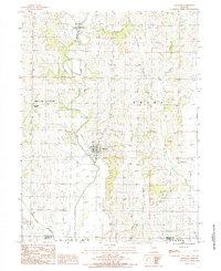
1984 Map of Barnard
USGS Topo · Published 1985About this map
The One Hundred and Two River snakes through the center of this Northwest Missouri landscape, defining the topography around Barnard. By the early 1980s, the local transportation network had shifted, leaving an Old Railroad Grade as a physical marker of the region's former rail-dependent economy. To the west, the small settlement of Pumpkin Center sits near the headwaters of White Cloud Creek, while the eastern portion of the map is drained by Long Branch and the Platte River. Several Quarries and a Quarry indicate the local extraction of stone, a vital industry alongside traditional agriculture. Recreational and conservation land is represented by the Black-Oak Public Access along the river, illustrating the balance of land use between the townships of White Cloud and Grant.
Find a feature on this map
20 named features on this map. Tap any name to fly to it.
Don’t see what you’re looking for? This feature index may not catch every label — zoom into the map to look around manually.
Map Details
Editions of this 1984 Barnard Map
This is the sole edition of this map. No revisions or reprints were ever made.
Other maps of this area

1925 · Stanberry
USGS Topo · 1:62,500

1927 · Bolckow
USGS Topo · 1:62,500

1939 · Stanberry
USGS Topo · 1:62,500

1940 · Parnell
USGS Topo · 1:62,500

1943 · Parnell
USGS Topo · 1:62,500

1943 · Maryville
USGS Topo · 1:62,500

1943 · Stanberry
USGS Topo · 1:62,500

1945 · Bolckow
USGS Topo · 1:62,500

1955 · Nebraska City
USGS Topo · 1:250,000

1957 · Nebraska City
USGS Topo · 1:250,000