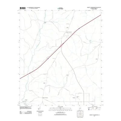
2011 Map of Barnett Crossroads
USGS Topo · Published 2011About this map
Big Escambia Creek winds through this Escambia County landscape, defining the topography of a region anchored by small rural settlements and family landmarks. The area around Barnett Crossroads and Pineview is characterized by a network of local roads such as Gus Searcy Rd and Grissett Bridge Rd, which connect scattered homesteads and timberlands. For genealogists and local historians, several burial grounds are documented, including Hawkins Cemetery, Magnolia Cemetery, and Emmons Cemetery. A distinctive feature in the southern portion of the sheet is the Maschmeyer Lookout Tower, standing near the community of Pineview. Waterways like Broken Leg Creek and Narrow Gap Creek feed into the larger creek system, crossed by structures like Gressett Bridge and Sardine Bridge. The map also captures the settlement of Sardine near the southwestern corner, illustrating the quiet, rural character of southern Alabama at the start of the 2010s.
Find a feature on this map
48 named features on this map. Tap any name to fly to it.
Don’t see what you’re looking for? This feature index may not catch every label — zoom into the map to look around manually.
Map Details
Editions of this 2011 Barnett Crossroads Map
This is the sole edition of this map. No revisions or reprints were ever made.
Other maps of this area

1953 · Andalusia
USGS Topo · 1:250,000

1957 · Andalusia
USGS Topo · 1:250,000

1960 · Atmore
USGS Topo · 1:24,000

1960 · Huxford
USGS Topo · 1:24,000

1960 · Pollard
USGS Topo · 1:24,000

1960 · Barnett Crossroads
USGS Topo · 1:24,000

1960 · Wallace
USGS Topo · 1:24,000
1960 · Flomaton
USGS Topo · 1:24,000

1971 · Range
USGS Topo · 1:24,000

1972 · Frisco City SE
USGS Topo · 1:24,000