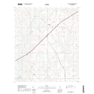
2018 Map of Barnett Crossroads
USGS Topo · Published 2018About this map
Barnett Crossroads and Stanley Crossroads anchor this Escambia County landscape, where the rural topography is defined by the winding course of Big Escambia Creek and its various tributaries. The map shows a region shaped by its hydrology, with notable water bodies including Broken Leg Cr, Dean Cr, and Narrow Gap Cr. For those researching local family histories, the inclusion of Hawkins Cem, Emmons Cem, and Magnolia Cem provides specific points of interest tied to early settlement families.
Find a feature on this map
54 named features on this map. Tap any name to fly to it.
Don’t see what you’re looking for? This feature index may not catch every label — zoom into the map to look around manually.
Map Details
Editions of this 2018 Barnett Crossroads Map
This is the sole edition of this map. No revisions or reprints were ever made.
Other maps of this area

1953 · Andalusia
USGS Topo · 1:250,000

1957 · Andalusia
USGS Topo · 1:250,000

1960 · Atmore
USGS Topo · 1:24,000

1960 · Huxford
USGS Topo · 1:24,000

1960 · Pollard
USGS Topo · 1:24,000

1960 · Barnett Crossroads
USGS Topo · 1:24,000

1960 · Wallace
USGS Topo · 1:24,000
1960 · Flomaton
USGS Topo · 1:24,000

1971 · Range
USGS Topo · 1:24,000

1972 · Frisco City SE
USGS Topo · 1:24,000