
1958 Map of Barr Creek
USGS Topo · Published 1960About this map
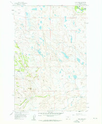
Sun River Game Range Headquarters serves as a focal point in this 1950s landscape, positioned near the base of rising terrain along Rose Creek. The map documents a complex water management system essential to this part of Montana, featuring the Willow Creek Feeder Canal, Geldrich Ditch, and the Kirkaldie Canal. These man-made channels diverge from natural drainages like Barr Creek and Willow Creek, illustrating the historical engineering required to support ranching operations such as the Morris Ranch. North of the winding waterways, the topography levels out into the Alkali Flat, contrasted by the prominent elevation of Black Butte. The map also captures the county line where Lewis and Clark and Teton counties meet at the North Fork Sun River, providing a clear record of mid-century rural boundaries and resource use.
Find a feature on this map
18 named features on this map. Tap any name to fly to it.
Don’t see what you’re looking for? This feature index may not catch every label — zoom into the map to look around manually.
Map Details
Editions of this 1958 Barr Creek Map
2 editions found
Other maps of this area

1903 · Saypo
USGS Topo · 1:125,000

1903 · Coopers Lake
USGS Topo · 1:125,000

1920 · Choteau
USGS Topo · 1:125,000

1943 · Hogan
USGS Topo · 1:125,000

1955 · Choteau
USGS Topo · 1:250,000

1957 · Choteau
USGS Topo · 1:250,000

1958 · Choteau
USGS Topo · 1:250,000

1958 · Sawtooth Ridge
USGS Topo · 1:24,000

1958 · Castle Reef
USGS Topo · 1:24,000
1958 · Split Rock Lake
USGS Topo · 1:24,000