
1958 Map of Castle Reef
USGS Topo · Published 1960About this map
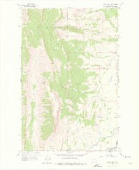
Lewis and Clark National Forest dominates the western half of this 1958 survey, where the dramatic ridgeline of Castle Reef rises above Hannan Gulch. This high-altitude landscape is defined by the headwaters of the Sun River system, including No Business Creek and the N Fk Sun R. To the east, the terrain transitions into ranching country at the edge of the Forest Boundary. Isolated outposts like Kellogg Ranch and Doty High Ranch are situated near the seasonal drainages of Battle Creek. Evidence of early water management is visible in the lower elevations through the Pishkun Canal, which draws from the mountain runoff to service the drier plains near Alkali Flat.
Find a feature on this map
19 named features on this map. Tap any name to fly to it.
Don’t see what you’re looking for? This feature index may not catch every label — zoom into the map to look around manually.
Map Details
Editions of this 1958 Castle Reef Map
2 editions found
Other maps of this area

1903 · Saypo
USGS Topo · 1:125,000

1955 · Choteau
USGS Topo · 1:250,000

1957 · Choteau
USGS Topo · 1:250,000

1958 · Choteau
USGS Topo · 1:250,000

1958 · Ear Mountain
USGS Topo · 1:24,000

1958 · Lake Theboe
USGS Topo · 1:24,000

1958 · Our Lake
USGS Topo · 1:24,000

1958 · Barr Creek
USGS Topo · 1:24,000

1958 · Sawtooth Ridge
USGS Topo · 1:24,000

1958 · Patricks Basin
USGS Topo · 1:24,000