
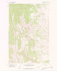
1958 Map of Ear Mountain
USGS Topo · Published 1959About this map
Lewis and Clark National Forest dominates this landscape along the eastern edge of the Rockies, where the high peaks of the Front Range give way to the plains of Teton County. At the time of this 1958 field check, the Ear Mountain Ranger Station stood as a key outpost for mountain management near the base of the prominent Ear Mountain. The map captures a transitional wilderness where the Teton River and the South Fork Teton River emerge from deep canyons such as Riordon Gulch.
Find a feature on this map
28 named features on this map. Tap any name to fly to it.
Don’t see what you’re looking for? This feature index may not catch every label — zoom into the map to look around manually.
Map Details
Editions of this 1958 Ear Mountain Map
2 editions found
Other maps of this area

1903 · Saypo
USGS Topo · 1:125,000

1955 · Choteau
USGS Topo · 1:250,000

1957 · Choteau
USGS Topo · 1:250,000

1958 · Choteau
USGS Topo · 1:250,000

1958 · Lake Theboe
USGS Topo · 1:24,000

1958 · Cave Mountain
USGS Topo · 1:24,000

1958 · Mount Wright
USGS Topo · 1:24,000
1958 · Twin Lakes
USGS Topo · 1:24,000

1958 · Our Lake
USGS Topo · 1:24,000

1958 · Castle Reef
USGS Topo · 1:24,000