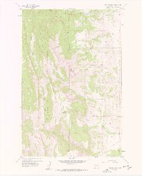
1958 Map of Ear Mountain
USGS Topo · Published 1959About this map
Ear Mountain and Chute Mountain anchor this high-altitude landscape along the eastern front of the Rocky Mountains. Published in 1959, the survey documents a wilderness terrain defined by the Lewis and Clark National Forest boundary and a complex network of drainages including the South Fork Teton River and Willow Creek. The absence of developed roads is striking, with transportation limited to a Pack Trail and Jeep Trail system that likely served the Ear Mountain Ranger Station in the northeast corner of the quadrangle.
Find a feature on this map
25 named features on this map. Tap any name to fly to it.
Don’t see what you’re looking for? This feature index may not catch every label — zoom into the map to look around manually.
Map Details
Editions of this 1958 Ear Mountain Map
2 editions found
Other maps of this area

1903 · Saypo
USGS Topo · 1:125,000

1955 · Choteau
USGS Topo · 1:250,000

1957 · Choteau
USGS Topo · 1:250,000

1958 · Choteau
USGS Topo · 1:250,000

1958 · Ear Mountain
USGS Topo · 1:24,000

1958 · Lake Theboe
USGS Topo · 1:24,000

1958 · Cave Mountain
USGS Topo · 1:24,000

1958 · Mount Wright
USGS Topo · 1:24,000
1958 · Twin Lakes
USGS Topo · 1:24,000

1958 · Our Lake
USGS Topo · 1:24,000