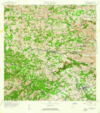
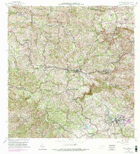
1957 Map of Barranquitas
USGS Topo · Published 1960About this map
Barranquitas serves as the central hub of this mid-century topographic study, which illustrates the intricate social and educational infrastructure of the Puerto Rican central cordillera. The mapping highlights an extensive network of rural schools, including the Escuela Segunda Unidad de Federico Degetau and the Escuela Segunda Unidad de José Celso Barbosa, reflecting a period of significant investment in regional education. The terrain is defined by the headwaters of the Río Grande de Manatí and the Río Coamo, where agriculture and industry meet at sites like Hacienda Ortega and a local Cantera. Settlement patterns are concentrated around traditional barrios such as Helechal and La Vega, while the southern reaches of the quadrangle near Pueblo Norte and Pueblo Sur show the early development of Aibonito.
Find a feature on this map
69 named features on this map. Tap any name to fly to it.
Don’t see what you’re looking for? This feature index may not catch every label — zoom into the map to look around manually.
Map Details
Editions of this 1957 Barranquitas Map
5 editions found
Other maps of this area

1945 · Rio Descalabrado
USGS Topo · 1:30,000

1946 · Coamo
USGS Topo · 1:30,000

1946 · Corozal
USGS Topo · 1:30,000

1946 · Barranquitas
USGS Topo · 1:30,000

1946 · Ciales
USGS Topo · 1:30,000

1946 · Cayey
USGS Topo · 1:30,000

1946 · Comerio
USGS Topo · 1:30,000

1946 · Naranjito
USGS Topo · 1:30,000

1946 · Orocovis
USGS Topo · 1:30,000

1947 · Corozal SO
USGS Topo · 1:10,000
Featured Places
- Aibonito
- Barranquitas
- Sector Los Pinos, Aibonito
- Parcelas de Helechal, Barranquitas
- Comunidad Bárbara Santiago, Barranquitas