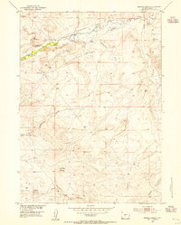
1953 Map of Barras Springs
USGS Topo · Published 1955About this map
The Oregon Trail cuts a historic path across this high plains landscape, paralleling the serpentine course of the Sweetwater River as it flows past Beaver Rim. This mid-century survey documents a region defined by early westward migration and sparse ranching, anchored by the St Marys Station (Historic) and the Ellis Ranch. Evidence of irrigation efforts is visible through the Arnold Ditch No 1 and Brown Ditch, which divert water to the river's adjacent flats.
Find a feature on this map
24 named features on this map. Tap any name to fly to it.
Don’t see what you’re looking for? This feature index may not catch every label — zoom into the map to look around manually.
Map Details
Editions of this 1953 Barras Springs Map
3 editions found
Other maps of this area

1953 · Lewiston Lakes
USGS Topo · 1:24,000

1953 · Barras Springs
USGS Topo · 1:24,000

1953 · Sweetwater Station
USGS Topo · 1:24,000

1953 · Happy Spring
USGS Topo · 1:24,000

1953 · Schlichting Mountain
USGS Topo · 1:24,000

1953 · Red Canyon
USGS Topo · 1:24,000

1955 · Lander
USGS Topo · 1:250,000
1957 · Red Canyon
USGS Topo · 1:24,000

1958 · Lander
USGS Topo · 1:250,000
1958 · Schoettlin Mountain
USGS Topo · 1:24,000