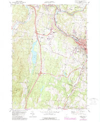
1978 Map of Barre West
USGS Topo · Published 1988About this map
The Winooski River and the Central Vermont rail corridor define the industrial and transit backbone of the Barre-Montpelier area in the late 1970s. This map illustrates the vital connections between Barre, South Barre, and Berlin Corners, anchored by the Edward F Knapp State Airport. The landscape is a mix of granite-related industry, evidenced by the Quarry labels, and historic settlement patterns represented by numerous burial grounds such as Hope Cem, St Monica Cem, and the West Hill Cem. The topographic detail highlights the significant elevation changes between the river valleys and peaks like Paine Mtn and Irish Hill. Institutional footprints are prominent, including the Union High Sch and several radio towers, reflecting the region's role as a population and communication hub for Washington and Orange Counties.
Find a feature on this map
44 named features on this map. Tap any name to fly to it.
Don’t see what you’re looking for? This feature index may not catch every label — zoom into the map to look around manually.
Map Details
Editions of this 1978 Barre West Map
3 editions found
Other maps of this area

1919 · Montpelier
USGS Topo · 1:62,500

1921 · Montpelier
USGS Topo · 1:62,500

1922 · Barre
USGS Topo · 1:48,000

1924 · Barre
USGS Topo · 1:62,500

1939 · Plainfield
USGS Topo · 1:48,000
1940 · Plainfield
USGS Topo · 1:62,500

1943 · Plainfield
USGS Topo · 1:62,500
1944 · Montpelier
USGS Topo · 1:62,500

1947 · Corinth
USGS Topo · 1:62,500

1948 · East Barre
USGS Topo · 1:62,500