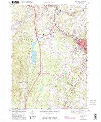
1978 Map of Barre West
USGS Topo · Published 1988About this map
Berlin and Barre define the central corridor of this 1970s Vermont landscape, where the Central Vermont railroad line and the Winooski River trace the valley floor. The map documents a period of infrastructure expansion, highlighted by the prominence of the Edward F Knapp State Airport and the complex road network connecting Berlin Corners to the industrial and residential centers. The presence of numerous family-named burial grounds, including Wright Cem, Loomis Cem, and Berlin Cem, provides significant value for genealogists tracing local lineage in Washington County. Significant water features like Berlin Pond and the Bolster Reservoir dominate the western and southern reaches, while the transition from the city core to the rising elevations of West Hill and Goldsbury Hill reveals the region's traditional settlement patterns and land use.
Find a feature on this map
55 named features on this map. Tap any name to fly to it.
Don’t see what you’re looking for? This feature index may not catch every label — zoom into the map to look around manually.
Map Details
Editions of this 1978 Barre West Map
3 editions found
Other maps of this area

1919 · Montpelier
USGS Topo · 1:62,500

1921 · Montpelier
USGS Topo · 1:62,500

1922 · Barre
USGS Topo · 1:48,000

1924 · Barre
USGS Topo · 1:62,500

1939 · Plainfield
USGS Topo · 1:48,000

1940 · Plainfield
USGS Topo · 1:62,500

1943 · Plainfield
USGS Topo · 1:62,500

1944 · Montpelier
USGS Topo · 1:62,500

1947 · Corinth
USGS Topo · 1:62,500

1948 · East Barre
USGS Topo · 1:62,500